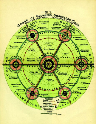
꼬르뷔제의 계획이 종이 위에 표현 되지 않았다면 그 힘을 발휘하지 못하였을 것이다. 그는 1930년 당시 급진적인 생각을 가진 것으로 평가되었으나 그의 다이어그램이 상상력을 일깨워 주었다. 이와 같이 도시계획을 바꾼 다이어그램 전시회인 "Grand Reductions: Ten diagrams that changed urban planning"이 San Francisco Planning and Urban Research Association의 주최로 열리고 있다. 추상적인 개념을 단순한 일러스트레이션으로 보여주는 전시회이다. 안타깝게도 조금 먼 샌프란시스코에서 내년 2월까지 열린다. 무료입장이다.
1. Ebenezer Howard’s Garden City

Courtesy of the Town and Country Planning Association
2. Le Corbusier’s Radiant City

From Le Corbusier's "The Radiant City" (1933)

United States Geological Survey
3. Frank Lloyd Wright’s Broadacre City

Courtesy the Frank Lloyd Wright Foundation Archives
4. The Street Grid

Courtsey David Rumsey Map Collection
5. The Megaregion

From Jean Gottamn's "Megalopolis"
6. The Transect

Courtesy Andres Duany
7. The Setback Principle

From New York's 1916 Zoning Resolution

The Library of Congress
8. The Nolli Map

Courtesy the University of California Berkeley Library
9. Psychogeography

From Kevin Lynch, "The Image of the City" (1960)
10. The Hockey Stick

Courtesy Michael Mann
http://blog.daum.net/abrief
No comments:
Post a Comment